By: Kyle N.
Project blue book, - was one of a series of systematic studies of Unidentified flying objects (UFOs) conducted by the United States Air Force (U.S.A.F.). Started in 1952, it was the second revival of such a study. A termination order was given for the study in December 1969, and all activity under its auspices ceased in January 1970.
Project Blue Book had two goals: to determine if UFOs were a threat to national security, and to scientifically analyze UFO-related data. Thousands of UFO reports were collected, analyzed and filed. As the result of the Condon Report, which concluded there was nothing anomalous about any UFOs, Project Blue Book was ordered shut down in December 1969. This project was the last publicly known UFO research project led by the USAF.[1]
By the time Project Blue Book ended, it had collected 12,618 UFO reports, and concluded that most of them were misidentifications of natural phenomena (clouds, stars, et cetera) or conventional aircraft. A few were considered hoaxes. 701 of the reports — about six percent — were classified as unknowns, defying detailed analysis.[2] The UFO reports were archived and are available under the Freedom of Information Act, but names and other personal information of all witnesses have been redacted.
Though many accepted Blue Book's final conclusions that there was nothing extraordinary about UFOs, critics — then and now — have charged that Blue Book, especially in its later years, was engaging in dubious research, or even perpetuating a cover up of UFO evidence. Some evidence suggests that not only did some UFO reports bypass Blue Book entirely, but that the U.S. Air Force continued collecting and studying UFO reports after Blue Book had been discontinued, despite official claims to the contrary
Public USAF UFO studies were first initiated under Project Sign at the end of 1947, following many widely publicized UFO reports (see Kenneth Arnold). Project Sign was initiated specifically at the request of General Nathan Twining, chief of the Air Force Materiel Command at Wright-Patterson Air Force Base. Wright-Patterson was also to be the home of Project Sign and all subsequent official USAF public investigations.
Sign was officially inconclusive regarding the cause of the sightings. However, according to U.S Air Force Captain Edward J. Ruppelt (the first director of Project Blue Book), Sign's initial intelligence estimate (the so-called Estimate of the Situation) written in the late summer of 1948, concluded that the flying saucers were real craft, were not made by either the Russians or U.S., and were likely extraterrestrial in origin. (See also extraterrestrial hypothesis.) This estimate was forwarded to the Pentagon, but subsequently ordered destroyed by Gen. Hoyt Vandenberg, USAF Chief of Staff, citing a lack of physical proof. Vandenberg subsequently dismantled Project Sign.
Project Sign was succeeded at the end of 1948 by Project Grudge, which had a debunking mandate. Ruppelt referred to the era of Project Grudge as the "dark ages" of early USAF UFO investigation. Grudge concluded that all UFOs were natural phenomena or other misinterpretations, although it also stated that 23 percent of the reports could not be explained.
the majestic 12
The primary evidence for the existence of a group named Majestic twelve is a collection of documents that first emerged in 1984 and which have been the subject of much debate. The original MJ-12 documents state that:
The Majestic 12 group... was established by order of President Truman on 24 September, [sic - see discussion] 1947, upon recommendation by Dr. Vannevar Bush and Secretary of Defense James Forrestal.[1]
The existence of MJ-12 has sometimes been denied by some agencies of the United States government, which insist that documents suggesting its existence are hoaxes. The FBI investigated the documents, and concluded they were forgeries, based primarily on an opinion rendered by AFOSI, the U.S. Air Force Office of Special Investigations. Opinions among UFO researchers are divided: Some argue the documents may be genuine while others contend they are phony, primarily due to errors in formatting and chronology.
Note: time is fixed, we are the ones that move. Time has no past, present, or future, we have past, present and future. Judging a ducument on chronology with MJ-12 is a bad idea. When agents die and wake up, time become meaningless.
In 1985, another document mentioning MJ-12 and dating to 1954 was found in a search at the National Archives.[2] Its authenticity is also highly controversial. The documents in question are rather widely available on the Internet, for example on the FBI website, where they are dismissed as bogus (linked below).
Since the first MJ-12 documents, thousands of pages of other supposed leaked government documents mentioning MJ-12 and a government coverup of UFO reality have also appeared, sometimes collectively referred to as the "Majestic Documents."[3] All of them are controversial, with many disputing their authenticity. A few have been proven to be unquestionably fraudulent, usually retyped rewrites of unrelated government documents. The primary new MJ-12 document is a lengthy, linotype-set manual allegedly dating from 1954, called the MJ-12 "Special Operations Manual (SOM)". It deals primarily with the handling of crash debris and alien bodies.[4] Objections to its authenticity usually center on questions of style and some historical anachronisms.
The MJ-12 documents are alleged to date from 1942 to 1997 and have been hotly debated in the UFO community. The documents include such matters as the conduct to be used when meeting an alien, diagrams and records of tests on UFOs, memos on assorted coverups, and descriptions of the President's statements about UFO-related issues. The documents contain supposed signatures of important people such as Albert Einstein and Ronald Reagan, creating a major debate in the conspiracy and UFO communities. No more documents have been leaked or released since 1997. Their authenticity remains uncertain, and some claim them to be entirely fake.
However, before the appearance of the various dubious MJ-12 documents, Canadian documents dating from 1950 and 1951 were uncovered in 1978.[5] These documents mention the existence of a similar, highly classified UFO study group operating within the Pentagon's Research & Development Board (RDB) and headed by Dr. Vannevar Bush. Although the name of the group is not given, proponents argue that these documents remain the most compelling evidence that such a group did exist. There is also some testimony (see Arguments for below) from a few government scientists involved with this project confirming its existence.
Other theories of the MJ-12 group
MJ-12 is sometimes associated[citation needed] in recent UFO conspiracy literature with the more historically verifiable but also deeply secretive NSC 5412/2 Special Group, created by President Dwight D. Eisenhower in 1954. Although the Special Group was not specifically concerned with UFOs, and post-dates the alleged creation of MJ-12 in 1947, the commonality of the number '12' in the names of the two groups is cited as intriguing, as is the first chairman, Gordon Gray, being one of the alleged MJ-12 members. As the highest body of central intelligence experts in the early Cold War era (the Group was alleged to include the President but exclude the Vice President), the Special Group certainly would have had both clearance and interest in all matters of national security, including UFO sightings if they were considered a real threat.
Others have speculated that MJ-12 may have been another name for the Interplanetary Phenomenon Unit, an officially recognized UFO-related military group active from the 1940s through the late 1950s.
Another government group recently associated with MJ-12 was the CIA's Office of National Estimates or ONE, a forerunner of the current National Intelligence Council (NIC). ONE was created in 1950 by CIA Director Gen. Walter Bedell Smith, alleged to have replaced Secretary of Defense James Forrestal on MJ-12 after his death. A history of the NIC states that ONE was a type of super branch of the CIA "whose sole task was to produce coordinated 'National Intelligence Estimates.'" [6] Besides Smith, it apparently consisted of 11 other members. A recent article on the history of the CIA's involvement in UFO investigations states that ONE received a UFO intelligence briefing on January 30, 1953, immediately after the end of the CIA's UFO debunking study known as the Robertson Panel. Members of ONE at that time included FBI director J. Edgar Hoover, William Bundy, President Eisenhower's chief of staff Admiral B. Bieri, and William Langer, a Harvard historian, who was chairman. Referring to ONE as "super think tank" within the CIA, the article states, "ONE is as close as we get to a documented version of the rumoured Majestic-12 group." [7]
the infamouse Area 51
Groom Lake is not a conventional airbase, as frontline units are not normally deployed there. It instead appears to be used during the development, testing, and training phases for new aircraft. Once these aircraft have been approved by the United States Air Force or other agencies such as the CIA, operation of that aircraft is generally conducted from a normal air force base. Groom is reported, however, to be the permanent home for a small number of Soviet-designed aircraft (obtained by various means),[12] which are analyzed and used for training purposes.
Soviet spy satellites obtained photographs of the Groom Lake area during the height of the Cold War, and later civilian satellites produced detailed images of the base and its surroundings. These images support only modest conclusions about the base; they depict a nondescript base, long airstrip, hangars and the lake, but nothing that supports some of the claims about underground facilities.
Though no ICAO identifier for the base appears on any official document, in December 2007, airline pilots noticed that the base had appeared in their aircraft navigation systems' latest Jeppesen database revision as "KXTA".[13]
U-2 program
Groom Lake was used for bombing and artillery practice during World War II, but was then abandoned until 1955, when it was selected by Lockheed's Skunk Works team as the ideal location to test the forthcoming U-2 spy plane.[14] The lakebed made an ideal strip from which they could operate the troublesome test aircraft, and the Emigrant Valley's mountain ranges and the NTS perimeter protected the test site from prying eyes and outside interference.
Lockheed constructed a makeshift base at Groom, consisting of little more than a few shelters, workshops and trailer homes in which to house its small team. The first U-2 flew at Groom in August 1955, and U-2s under the control of the CIA began overflights of Soviet territory by mid-1956.
During this period, the NTS continued to perform a series of atmospheric nuclear explosions. U-2 operations throughout 1957 were frequently disrupted by the Plumbbob series of atomic tests, which detonated over two-dozen devices at the NTS. The Plumbbob-Hood explosion on July 5 scattered fallout across Groom and forced a temporary evacuation.
As the U-2's primary mission was to fly over the Soviet Union, it operated largely from airbases near the Soviet border, including Incirlik in Turkey, Peshawar in Pakistan, and Bodø, Norway.
Blackbird programs

Even before U-2 development was complete, Lockheed began work on its successor, the CIA's OXCART project, a Mach-3 high altitude reconnaissance aircraft, a later variant of which became the famed USAF SR-71 Blackbird. The Blackbird's flight characteristics and maintenance requirements forced a massive expansion of facilities and runways at Groom Lake. By the time the first A-12 Blackbird prototype flew at Groom in 1962, the main runway had been lengthened to 8500 ft (2600 m), and the base boasted a complement of over 1000 personnel. It had fueling tanks, a control tower, and a baseball diamond. Security was greatly enhanced, the small civilian mine in the Groom basin was closed, and the area surrounding the valley was made an exclusive military preserve (where interlopers could be subject to "lethal force"). Groom saw the first flight of all major Blackbird variants: A-12, SR-71, its abortive YF-12 interceptor variant, and the D-21 Blackbird-based drone project. The A-12 would remain at Groom Lake until 1968.
Have Blue/F-117 program
The first Lockheed Have Blue prototype stealth fighter (a smaller cousin of the F-117 Nighthawk) first flew at Groom in December 1977.[15] Testing of a series of ultra-secret prototypes continued there until mid-1981, when testing transitioned to the initial production of F-117 stealth fighters. In addition to flight-testing, Groom performed radar profiling, F-117 weapons testing, and was the location for training of the first group of frontline USAF F-117 pilots. Subsequently, the still highly classified active-service F-117 operations moved to the nearby Tonopah Test Range, and finally to Holloman Air Force Base.
Since the F-117 became operational in 1983, operations at Groom Lake have continued unabated. The base and its associated runway system have been expanded, and daily flights bringing civilian commuters from Las Vegas continue. Some commentators, after examining recent satellite photos of the base, estimate it to have a live-in complement of over 1000 people, with a similar number commuting from Las Vegas. In 1995, the federal government expanded the exclusionary area around the base to include nearby mountains that had hitherto afforded the only decent overlook of the base. Subsequently, limited views of the area are available only from the summits of several distant mountains east.
Aircraft that have been tested at Groom include the Northrop Tacit Blue stealth demonstrator, various classified UAVs, and a stealthy cruise missile (most likely the AGM-129 Advanced Cruise Missile). Other rumored Groom test programs include a small stealthy VTOL troop-transport aircraft, the Aurora hypersonic spy plane, a "Stealth Blimp", a secret USAF spaceplane codenamed Blackstar,[16] and replacements for the SR-71 and F-117A.
Area 51 commuters
Defense contractor EG&G maintains a private terminal 36°05′31″N 115°09′54″W / 36.092, -115.165 at McCarran International Airport in the Las Vegas metropolitan area. A number of unmarked aircraft operate daily shuttle services from McCarran to sites operated by EG&G in the extensive federally controlled lands in southern Nevada. These aircraft reportedly use JANET radio call signs (e.g., "JANET 6") (the JANET airplanes are now using either call sign "Bland" or "JANET" on the radio, and "WWW" on their flight number identifier), said to be an acronym for "Joint Air Network for Employee Transportation" or (perhaps jokingly) "Just Another Non-Existent Terminal". EG&G advertises in the Las Vegas press for experienced military pilots, requiring applicants to be eligible for government security clearance, and that successful applicants can expect to always stay overnight at Las Vegas. These aircraft, painted white with red trim (the livery of now defunct Western Airlines), include six Boeing 737/T-43As and several smaller turboprops. Their tail numbers are registered to the U.S. Air Force. They are reported to shuttle to Groom, Tonopah Test Range, to other locations in the NAFR and NTS, and reportedly to Naval Air Weapons Station China Lake. Observers tracking the number of departures and cars in the private EG&G parking lot at McCarran estimate several thousand JANET commuters each day. These shuttle flights were previously operated by Key Air, which had flown 22,000 passenger trips on 300 flights from Nellis Air Force Base to Tonopah Test Range per month from 1982 until early 1991.[citation needed]

Commuter service is provided along Groom Lake Road by a bus, catering to a small number of employees living in several small communities beyond the NTS boundary (although it is not clear whether these workers are employed at Groom or at other facilities in the NTS). The bus travels Groom Lake Road and stops at Crystal Springs, Ash Springs, and Alamo, and parks at the Alamo courthouse overnight.
Runways
The airbase, given the ICAO airport identifier code of KXTA and listed as "Homey Airport"[17] in aviation GPS databases, has seven runways including one that now appears to be closed. The closed runway, 14R/32L, is also by far the longest with a total length of approximately 7,093 meters (23,270 feet), not including stopway. The other runways are two asphalt runways, the 14L/32R with a length of 3,658 meters (12,000 feet) and 12/30 with a length of 1,652 meters (5,420 feet), and four runways located on the salt lake. These four runways are 09L/27R and 09R/27L, which are both approximately 3,489 meters (11,440 feet), and 03L/21R and 03R/21L, which are both approximately 3,057 meters (10,030 feet).[18][19]
U.S. government's positions on Area 51

On July 14, 2003 the Federal Government admitted the facility's existence, tacitly conceding that the Air Force has an "operating location" near the lake, but does not provide any further information. The base is conspicuously absent from Federal publications and inquiries to the government regarding the facility are rejected for reasons of national security.
Unlike much of the Nellis range, the area surrounding the lake is permanently off-limits both to civilian and normal military air traffic. Radar stations protect the area, and unauthorized personnel are quickly expelled. Even military pilots training in the NAFR risk disciplinary action if they accidentally stray into the exclusionary "box" surrounding Groom's airspace.[20]

Perimeter security is provided by uniformed private security guards working for EG&G's security subcontractor Wackenhut,[21] who patrol in desert camouflage Jeep Cherokees and HMMWV vehicles, and more recently, champagne-colored Ford F-150 pickups and gray Chevy 2500 4X4 pickups. Although the guards are armed with M16s, no violent encounters with Area 51 observers have been reported; instead, the guards generally follow visitors near the perimeter and radio for the Lincoln County Sheriff. Deadly force is authorized if violators who attempt to breach the secured area fail to heed warnings to halt. Fines of around $600 seem to be the normal course of action, although some visitors and journalists report receiving follow-up visits from FBI agents. Some observers have been detained on public land for pointing camera equipment at the base. Surveillance is supplemented using buried motion sensors[22][23][24] and by HH-60 Pave Hawk helicopters.
The base does not appear on public U.S. government maps;[25] the USGS topographic map for the area only shows the long-disused Groom Mine,[26] and the civil aviation chart for Nevada shows a large restricted area,[27] but defines it as part of the Nellis restricted airspace. Similarly the National Atlas page showing federal lands in Nevada[28] does not distinguish between the Groom block and other parts of the Nellis range. Although officially declassified, the original film taken by U.S. Corona spy satellite in the 1960s has been altered prior to declassification; in answer to freedom of information queries, the government responds that these exposures (which map to Groom and the entire NAFR) appear to have been destroyed.[29] Terra satellite images (which were publicly available) were removed from web servers (including Microsoft's "Terraserver") in 2004,[30] and from the monochrome 1 m resolution USGS data dump made publicly available. NASA Landsat 7 images are still available (these are used in the NASA World Wind). Higher resolution (and more recent) images from other satellite imagery providers (including Russian providers and the IKONOS) are commercially available. These show, in considerable detail, the runway marking, base facilities, aircraft, and vehicles.
Nevada's state government, recognizing the folklore surrounding the base might afford the otherwise neglected area some tourism potential, officially renamed the section of State Route 375 near Area 51 "The Extraterrestrial Highway", and posted fancifully illustrated signs along its length.[31]
Although federal property within the base is exempt from state and local taxes, facilities owned by private contractors are not. Area 51 researcher Glenn Campbell claimed in 1994 that the base only declares a taxable value of $2 million to the Lincoln County tax assessor, who is unable to enter the area to perform an assessment.[32]
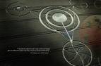
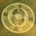
ok now lets talk about a new type of phenamenon
crop crcle, why are they here? we are not sure some think thaey are the signitures left behind fromthee ships that have landed there,
what do you think??


well the government is a conspiracy
if you didnt know that already just take a look around you, have you ever looked up at night and said "what else is out there?"?
truth is someone someTHING is out there, folks WE ARE NOT ALONE, some kind of extraterrestrial life force is out there and they have been here before and they are here now, and out there somewhere, watching and studying us from a distance, this is the proof.

ok the drone photos taken in california,,
1) Earthfiles • 05/30/2007 — Birmingham-Type “Drone” Seen At Barksdale AFB, Louisiana, in Mid-1980s
1987, Barksdale AFB, Louisiana:
In 1987, an eyewitness touring a Barksdale AFB air show saw a dragonfly-shaped craft in a hangar that was very similar to what the Birmingham, Alabama, military subcontractor photographed above power lines in May 2006. I have talked at length by phone with the engineer who toured Barksdale AFB in 1987. He does not want to jeopardize his career, but wants the public to know what he saw 21 years ago. I have his full name, address and phone number. In addition to the 1987 Barksdale AFB dragonfly craft and May 2006 dragonfly above power lines in Birmingham, Alabama, there was also a June 25, 2007, sighting near Maxwell-Gunter Air Force Base in Montgomery, Alabama, described by an infrared security technician in Part 2 of this Earthfiles report. That means between 1987 and 2007, in that one close region that includes Shreveport, Louisiansa along with Birmingham, and Montgomery, Alabama, there have been three military-related dragonfly drone encounters.
Barksdale AFB is in Shreveport, Louisiana, west of Birmingham, Alabama,
where military subcontractor photographed a simpler version of the dragonfly
drone in May 2006 (below). Southeast of Birmingham in Montgomery, Alabama, is
Maxwell-Gunter Air Force Base. Near there on June 25, 2007, an infrared security
technician had a close encounter with an aerial dragonfly drone detailed in Part 2.
2) Earthfiles • 06/22/2007 — Dragonfly "Drone" Seen October 1995 in Arizona
North of Tucson, Arizona, 1995:
Nine years later in October 1995, north of Tucson, Arizona, a dragonfly-shaped drone hovered within 20 feet of a hiker's head. He talked to me in June 2007 about the encounter, about how scared he was and how he did not want the government coming down on his head if it were a secret government project. That's why he never reported the event. But because I have been recording drone eyewitnesses, with or without real names and locations, he agreed to talk with me anonymously. He wants to know what the dragonfly-shaped drones are. I have his full name, address, phone number, where he works and his professional background.
3) Earthfiles • 05/25/2007 — Two More Eyewitnesses of Aerial “Drones”
in 2005 and 2006
Sequoia National Park, May 2005:
Ten years after that in May 2005 in Sequoia National Park, California, a retired California state mental health worker, told me she saw a dragonfly-shaped aerial craft. She has asked me to call her “Shirley P,” but I have her full name, address, phone, and employment background. She became very upset with internet rumors that all the drone photographs were faked CGI and Photoshop creations. She knew she had seen with her own eyes a strange aerial object that matched the Chad images of May 6, 2007. She saw the aerial machine while standing next to a Sequoia Park Ranger who was giving her directions and who told her the drone was used to look for fires. Shirley saw the same drone a second time in the park when she stopped to get further driving instructions from a road crew. She did not have a camera with her.
4) Earthfiles • 05/25/2007 — Two More Eyewitnesses of Aerial “Drones”
in 2005 and 2006
Birmingham, Alabama, May 2006:
The next year in May 2006, in Birmingham, Alabama, a military subcontractor I am calling “John Smith,” saw a dragonfly drone. As a subcontractor for the military, he cannot jeopardize his career. But he and I have corresponded by email and I have his full name, address and phone number. He took a photograph in May 2006 in a residential section of Birmingham, Alabama, with a Canon Digital camera. Mr. Smith was working near a construction site and heard a low buzzing sound like a transformer. He looked up and saw an aerial machine shaped like a dragonfly hovering above an electrical power pole.
Dragonfly-shaped aerial drone above power lines in Birmingham, Alabama,
in May 2006. Image © 2006 by military subcontractor.
Birmingham, Alabama, is east of Barksdale AFB in Shreveport, Louisiana,
where during an air show in 1987, the engineer (above) saw a dragonfly-shaped craft inside a hangar, which he says today closely resembled the aerial drone photographed by the military subcontractor in Birmingham in May 2006. Southeast of Birmingham in Montgomery,
Alabama, is Maxwell-Gunter Air Force Base. Near there on June 25, 2007,
an infrared security technician had a close encounter with an
aerial dragonfly drone detailed in Part 2.


5) Earthfiles • 06/08/2007 — More Drone Photos and Other Eyewitnesses
Northridge, California, near big shopping mall, May 17, 2006:
Also in May 2006, on the 17th, Robert Mariotti, a Clinical Hypnotherapist and Doctor of Divinity, in Canoga Park, California, spoke with me on the record about his sighting around 10 PM. He was stopped at a red light when the object “popped in” to view, not traveling from anywhere. He said the aerial object looked like a “horseshoe crab in profile,” glowing fluorescent apple green that sparkled like snow globe glitter.
“Brilliant, fluorescent apple green” aerial object, surrounded by glittering sparkles,
suddenly appeared only about ten feet above treetop on Corbin Avenue around 10 PM local time on May 17, 2006, at an intersection near the Northridge Shopping Mall. It reminded
Robert Mariotti of a snow globe after glitter-filled liquid is shaken up. Aerial object's
profile was like a horseshoe crab with long tail. Illustration © 2007 by Robert Mariotti.
When Robert Mariotti saw my Earthfiles reports, he contacted me by email and phone to say the “wires curving up above” and the long tail in the various photographs were also the same shape as the green fluorescent object that hovered motionless about ten feet above a tree at the Corbin Avenue intersection near the Northridge Mall. Another driver next to Robert also saw the object. After several seconds, the strange, green, glowing object moved forward about five feet and then disappeared by “popping out,” as it had popped in.
Daylight exterior of Corbin Avenue intersection, Northridge, California.
Arrow points at treetop where the glittering, fluorescent apple green, aerial object shaped
like a horseshoe crab suddenly “popped in” only a few feet above the tree around 10 PM,
May 17, 2006. Daylight photograph taken on June 14, 2007, to show street, tree and approximate location where Robert Mariotti and the driver next to him slammed
on their brakes. Photograph © 2007 by Robert Mariotti.


6) Earthfiles • 06/08/2007 — More Drone Photos and Other Eyewitnesses
Yosemite National Park, June 10, 2006:
A month later on June 10, 2006, a mother and her two sons were camping and saw a dragonfly-shaped drone for several minutes. The boys aimed their flashlights on it, which caused the drone to stop mid-air without sound or motion. When it moved again, it jerkily went in another direction and repeated that odd behavior several times whenever the boys aimed their flashlights on it. The mother sketched the aerial object which had a structure coming down from the ring similar to a different shape that appeared in California’s Big Basin Redwoods State Park in June 2007. The mother corresponded with me by email and sent me sketches of what she and her sons saw.
Sketch of dragonfly-shaped aerial object seen by mother
and two sons on June 10, 2006, in Yosemite National Park, California.
Aerial object stopped for several seconds in mid-air
when boys flashed light at drone.

Earthfiles • 05/16/2007 — Updated: Odd Aerial “Drones”?
Over Lake Tahoe and Central California
Lake Tahoe, May 5, 2007:
A year later on May 5, 2007, in Lake Tahoe, California, a person identifying themselves only as MUFON Submitter 7013, submitted two photographs of a dragonfly-shaped drone to UFOcasebook.com. I have had no independent communication with that photographer.
7) Earthfiles • 05/16/2007 — Updated: Odd Aerial “Drones”?
Over Lake Tahoe and Central California
Bakersfield, California, region, May 6, 2007:
But the next day on May 6, 2007, the man calling himself “Chad” took several clear, digital camera images of a dragonfly-shaped drone\ that was more complicated than the Lake Tahoe craft. Numbers, letters and symbols can be seen extending along the tail. I have corresponded several times with Chad and know his full name.
8) Earthfiles • 05/21/2007 — Updated: Odd Aerial “Drone”? Photographed Again Over Capitola, California
Capitola, California, east of Santa Cruz on Monterey Bay, May 16, 2007:
Ten days later on May 16, 2007, in Capitola, California, a man calling himself “Rajman1977” used his Konica Minolta DiMAGE X to photograph a dragonfly-shaped drone above a power pole that looks very similar to the Chad photos, except the Capitola drone has two box-like appendages on the ring. The Capitola drone also had symbols on its tail like Chad's photos.I know Rajman’s full name and corresponded with him in several emails. Rajman, like the others, was angered by and scared of potential ridicule in the wake of all the CGI/Photoshop attacks. “Rajman” was considering the possibility of doing an anonymous recorded interview with me, but decided against it and has not replied to further email inquiries since May 2007. The two hired private investigators featured in the Los Angeles Times on March 18, 2008, are lookiing for Rajman.


Then in early June 2007, UFOcasebook.com received a photograph of a more complicated and more sinister-looking version of the dragonfly-shaped drone allegedly photographed in the Big Basin Redwoods State Park of California, northwest of Santa Cruz, on June 5, 2007, by a person calling himself “Stephen.” I have not had independent communication with him.
9) Earthfiles • 06/17/2007 —More Big Basin, California, Bizarre "Drone" Images
Big Basin Redwoods State Park, California, June 5, 2007:
However, on that same day of June 5, 2007, another eyewitness bicycling in the Big Basin Redwoods Park also saw and photographed the complex, sinister-looking aerial machine. He calls himself “Ty B.,” and he emailed me about three encounters he had with a dragonfly-shaped aerial craft that looked like the “Stephen” images. Ty B. hard mailed me 12 photograph prints of the object he said kept turning slowly in the air not too far above where he and his cycling buddies stopped to watch and Ty photographed.


